Farmers of Tatarstan can determine the readiness of fields for harvesting by satellite images
This was told today at the Ministry of Agriculture and Food of the Republic of Tatarstan during a meeting with the districts.
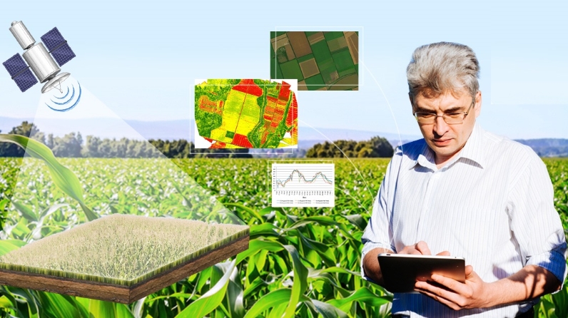
Digitalization is gaining importance in the agricultural sector of Tatarstan. Today, for example, using maps compiled and constantly updated on the basis of satellite images, it is possible to determine whether the fields are ready for harvesting.
RIVC General Director Niyaz Khaliullin noted that this allows taking the work of farm managers and agronomists to a completely new level without additional costs. The service is free. You don't have to go around the fields all the time. In addition, satellite monitoring allows you to see the entire field and analyze the ripening of the crop in different parts of it, which can be uneven. When driving out, it is often possible to check only the degree of ripening in the outer areas, but not in the middle of the fields.
In addition, by analyzing the degree of maturation of various fields on one farm, it is possible to rationally distribute the fleet of equipment and specialists involved in the harvesting campaign.
On a specialized portal, using the NDVI index, you can determine which fields are ready for harvesting - the lower the index, the closer the field is to ripening. The optimal value of the index in this case is 0.2-0.3. The moisture content of the grain can be determined by the SWIR index. You can find out more about this in the near future on the Agropoliya YouTube channel or consult the call center of the Ministry of Agriculture and Food of the Republic of Tatarstan by phone 8-800-444-16-70 (ext. 8).
Leading businesses have already taken advantage of the new opportunities. For example, the agricultural enterprise "Toyma" of the Kukmorsky region is actively working with the NDVI index.
Also during the meeting, they discussed the certification of fields, reporting on harvesting, unified identification of animals and the opportunity for agricultural enterprises to effectively position their goods and services.
For reference:
Precision farming often uses different vegetation indices, with the NDVI being the most popular. It allows you to assess the condition of the field and plants anywhere in the world using satellite images. We will tell in simple words what the vegetation index NDVI it has and how to use it when analyzing your fields.
The NDVI (Normalized Difference Vegetation Index) is a measure of plant health, which is calculated by how a plant reflects and absorbs different light waves.
For example, plants are green for our eyes because the chlorophyll pigment reflects green waves well. Chlorophyll also absorbs red waves: due to this, photosynthesis occurs, that is, the culture grows and develops. And the plant's cellular structure reflects near infrared waves. It turns out that a healthy plant, which has a lot of chlorophyll and a good cell structure, actively absorbs red light.